
Why Does It Rain? Convectional, Orographic and Cyclonic Rainfall — Visual Toolkit
One common cooling sequence and three ways to lift moist air.
Separate cold-front and warm-front cross-sections, with air motion and weather-map symbols.
Rain-shadow and tropical-cyclone traps, followed by a quick recall check.
📌 Revision Pointers
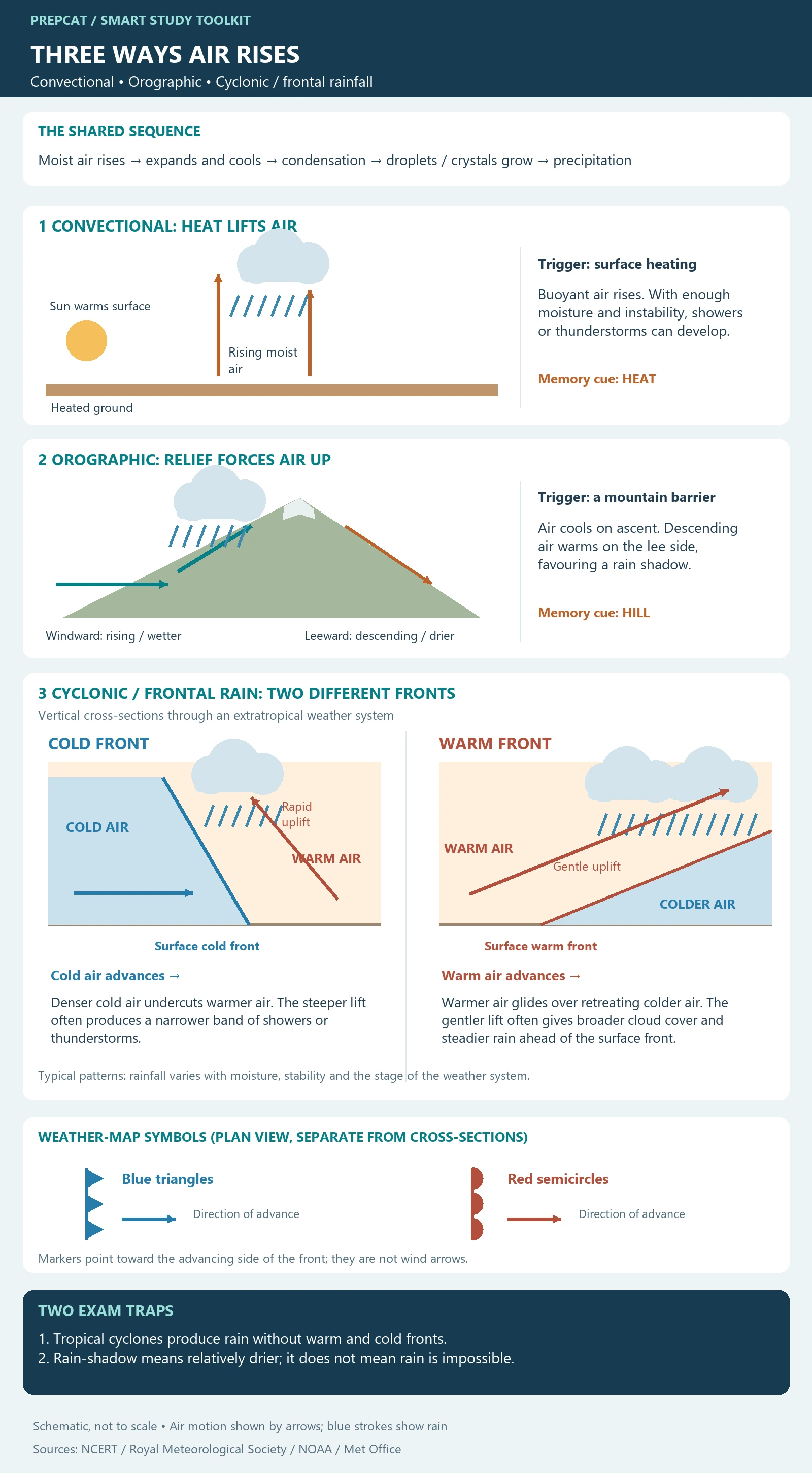
Shared sequence: Rise → expand and cool → condensation → precipitation if particles grow sufficiently.
HEAT: Buoyancy drives convectional ascent.
HILL: Relief forces air upward; the lee side can be relatively drier.
Cold front: Cold air advances underneath warm air; comparatively steep uplift.
Warm front: Warm air advances over retreating colder air; gentler uplift.
Symbols: Blue triangles = cold front; red semicircles = warm front. Markers indicate frontal advance.
Trap: Tropical cyclones are not frontal systems.
Overlap: Real rainfall can involve more than one lifting mechanism.
Start with the Lift
To distinguish rainfall mechanisms, ask: what makes moist air rise? Rising air encounters lower pressure, expands and cools. If it becomes saturated, condensation can form cloud droplets or ice crystals. They must grow sufficiently before falling as precipitation; not every rising parcel or cloud produces rain.
1. Convectional Rain: Heating from Below
Surface heating can make near-surface air buoyant. Under suitable moisture and instability, it rises and develops clouds; strong convection can produce showers and thunderstorms. The key clue is heating and buoyancy, not the presence of a mountain. It is common in warm conditions but is not restricted to a single latitude or hour.
2. Orographic Rain: Forced over Relief
Moist airflow encountering a mountain barrier can be forced upward, cool and produce precipitation. The side facing the incoming wind is windward. Descending air on the lee side warms, often making that side relatively drier: a rain shadow. Windward and leeward depend on wind direction, not fixed east–west labels.
Indian example: During moisture-bearing south-westerly flow, the western side of the Western Ghats receives strong orographic enhancement, while parts of the interior Deccan lie on the drier lee side. This is a broad mechanism, not a statement that the lee side never receives rain.
3. Cyclonic and Frontal Rain: Read the Qualification
Low-pressure systems can organise convergence and rising air. The infographic now separates two frontal mechanisms in an extratropical system. Both drawings are vertical cross-sections with the surface front advancing to the right.
Cold front: Advancing denser cold air undercuts warmer air and forces it upward along a comparatively steep boundary. With sufficient moisture and instability, a relatively narrow band of showers or thunderstorms can develop near the front.
Warm front: Advancing warmer air glides over retreating colder air along a gentler slope. Broader cloud cover and more prolonged, steadier precipitation commonly occur ahead of the surface warm front. These are typical patterns, not guarantees for every front.
Map symbols: A blue line with triangles marks a cold front; a red line with semicircles marks a warm front. The markers point in the direction of frontal advance, not the wind direction. These plan-view symbols are separate from the sloping cross-sections.
Sources: Met Office: Weather fronts; NOAA: Surface weather maps.
Critical distinction: Tropical cyclones also generate heavy rain through organised convection and circulation, but they are not frontal systems. Therefore, “cyclonic rainfall” must not be interpreted to mean that every cyclone has a warm or cold front.
The 20-Second Memory Hook
HEAT: buoyant ascent → convectional.
HILL: forced ascent over relief → orographic.
LOW / FRONT: organised lift; fronts are characteristic of the extratropical case shown.
The categories can overlap. A mountain can enhance rainfall within a cyclonic system, and a front can trigger convective clouds. Classify the dominant lifting process rather than assuming each real storm belongs to a sealed box.
Quick Self-Check
A. A mountain forces moist wind upward: orographic. B. Warm air rises after strong surface heating: convectional. C. Does every tropical cyclone need a front? No. D. Can a rain-shadow area still receive rain? Yes; the term describes a relative reduction.
Sources for Revision
NCERT: Water in the Atmosphere — rainfall mechanisms and relief rain.
NCERT: Climate, reproduced by SATHEE — Western Ghats and the rain-shadow example.
Royal Meteorological Society: Rainfall and Relief — lifting processes and overlapping mechanisms.
NOAA: What is a hurricane? — tropical cyclones have organised thunderstorms without fronts.
💭 Conclusion
Recall the lifting trigger first, then follow cooling, condensation and precipitation. Use the three mechanisms as a learning framework while remembering that terrain, convection and weather systems can interact.